There is an App that every field geologist should have, it is called "Theodolite."
It runs on iPhones and other smart phones in addition to iPads.
The App captures a photo and also records the coordinates, viewing direction and you can add notes to the photo. It stores a non-annotated photo too. It also shows location on a map.
Link to Website of Theodolite
These are some screen shots from their website.
The App can record the coordinates in several different projections with add on it can even record coordinates in State Plane. You will need to calibrate the compass on the iPhone so that it reads directions to True North.
Comments, articles and interesting items on geology and gold exploration. Interesting travel sites for geologists and mining enthusiasts. By a retired exploration geologist.
Friday, December 29, 2017
Thursday, September 28, 2017
Geology and Ore Deposit Stamps - South Africa
Earlier this year someone posted this on Linked In; stamps showing beautiful cross sections of ten ore deposits of South Africa.
Geology as Art
Geology Poster of the Geologic Cross Sections Stamps |
![]() |
Plate Block of the Stamps |
![]() |
Mineral Stamps from Africa |
Link to Geology Stamps from South Africa
Wednesday, August 9, 2017
Jamestown Gold Mine, CA: Mother Lode Exposed in Open Pit
In April 1992, I toured the Jamestown mine that is adjacent to Highway 49 in the Mother Lode district of California. I snapped a photo of the southern highwall of the pit. The mine was called the "Harvard Pit."
Hanging wall: Graphitic slate, metavolcanics. Quartz, albite, chlorite, sericite, graphite, ferroan dolomite, pyrite.
Ore Zone: Sheared fragments of hang wall and footwall rocks and quartz veins. Quartz, albite, mariposite, chlorite, sericite, talc, ferroan dolomite, magnesite, calcite, arsenian pyrite, native gold, sulfosalts, Au-Ag tellurides.
Footwall: Altered serpentinite, diorite, gabbro. Talc, tremolite, actinolite, chlorite, chromite, magnesite, gersdorffite, niccolite, millerite, colbaltite.
Gossan: Goethite, magnesiocopiapite, jarosite, gypsum, hexahydrite.
Source: Savage et.al.
![]() |
USGS 71/2' topo of the Jamestown area. |
![]() |
Google Earth image of the Jamestown area (Image May 2017) |
I snapped this photo in 1992 of the highwall of the pit. The mine was called the "Harvard Pit."
Harvard pit looking southeasterly. |
Geologic sketch of the Harvard pit showing the pit lake. Source: Savage, Ashley, Bird, 2000 +/-, Geology of the Jamestown mine, Mother Lode gold district CA, and geochemistry of the Harvard mine pit lake, USGS. Source: Link to PDF of Presentation
Harvard, Crystalline, and Alabama mines
Jamestown mine (Harvard pit)
|
Ore Zone: Sheared fragments of hang wall and footwall rocks and quartz veins. Quartz, albite, mariposite, chlorite, sericite, talc, ferroan dolomite, magnesite, calcite, arsenian pyrite, native gold, sulfosalts, Au-Ag tellurides.
Footwall: Altered serpentinite, diorite, gabbro. Talc, tremolite, actinolite, chlorite, chromite, magnesite, gersdorffite, niccolite, millerite, colbaltite.
Gossan: Goethite, magnesiocopiapite, jarosite, gypsum, hexahydrite.
Source: Savage et.al.
Friday, July 21, 2017
The Cove Open Pit Au-Ag Mine and Anticline, Nevada
I found a photo that I snapped in October 2000 of the Cove pit showing the well exposed anticline. October 2000 was the last month of open pit mining at the Cove. The anticline is no longer visible owing to the pit lake. It is great to see classic geological structures exposed in open pits, so I am posting it so that others can see the annotated photo.
The orebody is largely controlled by the crest of the anticline and favorable stratigraphic units of the Augusta Mountain Formation (Triassic). Three members of the formation are exposed in this view of the pit. In addition one of the Eocene felsic dikes filling a fault shows up as the light colored linear that stair steps through the benches. The post mineral Tuff of Cove Mine fills the erosional trough that is superimposed on the axis of the anticline owing to fracturing and hydrothermal alteration.
Premier Gold Mines Ltd. continues to explore the Cove/McCoy area and has had some significant intercepts of gold and silver at depths suitable for underground mining.
They released new (April 15, 2017) a technical report on the project. It is available on their website via this link: NI 43-101 McCoy-Cove Project, NV This excellent report is on the McCoy-Cove mineralization, the geology of the deposits and the current status of their exploration.
From Page 6-6 of their technical report, the total production from McCoy and Cove from 1986 through 2006 was 3.41 M ozs of gold and 110.2 M ozs of silver. The vast majority of the silver is from the Cove deposit and approximately 2.6 M ozs of gold is attributed the Cove deposit.
Monday, July 3, 2017
Brief History of the Theory of Plate Tectonics
I stumbled across my copy of the book Principles of Physical Geology written by Arthur Holmes in 1944. He wrote the book while Professor of Geology and Mineralogy at the University of Edinburgh. It is interesting that he wrote the book in the United Kingdom during World War II. The final chapter is on Continental Drift which is now called Plate Tectonics. He discusses the work of Alfred Wegener in the early 1900's and includes some of Wegner's reconstruction of the continents through geologic time. The final section is on the search for the mechanism for continental drift. He put forth the idea of convection cells a mechanism for the drift of the continents. He includes two cross section depicting the convection cells. One section shows the mid-oceanic ridges as spreading centers creating new oceans. It doesn't appear that he understood subduction zones.
It wasn't until the 1960's and 1970's that science proved that Wegener and Holmes were largely correct with their theory. It required new technology to uncover the "secrets" of plate tectonics: mapping of the ocean floors, marine magnetic surveys (using instruments designed in World War II to search for submarines), the discovery of the reversals of the earth's magnetic field, paleo magnetism, recognition that the mid-ocean ridges are spreading centers, a global network of sensors in the 1960's for the Nuclear Test-Ban Treaty of 1963, and deep sea core samples from the Glomar Challenger.
Key Events in the Formation of the Theory of Plate Tectonics
It wasn't until the 1960's and 1970's that science proved that Wegener and Holmes were largely correct with their theory. It required new technology to uncover the "secrets" of plate tectonics: mapping of the ocean floors, marine magnetic surveys (using instruments designed in World War II to search for submarines), the discovery of the reversals of the earth's magnetic field, paleo magnetism, recognition that the mid-ocean ridges are spreading centers, a global network of sensors in the 1960's for the Nuclear Test-Ban Treaty of 1963, and deep sea core samples from the Glomar Challenger.
![]() |
Dust jacket of Holmes' geology textbook. |
![]() |
Holmes' chapter on Continental Drift. |
![]() |
Wegener's reconstruction to the continents in Late Carboniferous, Eocene and Early Pleistocene (from Holmes,1944). |
![]() |
The cross sections from Holmes' chapter on Continental Drift. |
- 1596 Abraham Ortelius recognized that the coast of the Americas and Europe and Africa appear to have been joined a sometime and then pulled apart.
- 1912 Alfred Wegner hypothesized that the continents had a onetime all been joined together. He named the super continent Pangea. He termed the process continental displacement. Unfortunately during his lifetime the theory was not accepted by the scientific community.
- 1929 Arthur Holmes proposed that convection currents were mechanism of the movements of the continents and the formation of new oceans.
- 1950's Mapping of the topographic features of the ocean floor reveals underwater mountain ranges in the mid oceans with great vertical relief and extending for thousands of miles.
- 1960 Harry H. Hess, American geophysicist, proposed the idea that oceanic crust forms was from the mid-ocean ridges and spreads laterally in opposite directions.
- 1961 Robert S. Dietz, American geophysicist, named Hess' process as sea floor spreading and further advanced the theory of plate tectonics.
- 1963 Frederick J. Vine and Drummond H. Matthews, British geologists, and Laurence W. Morley, Canadian geophysicist, discovered the "magnetic strips" that symmetrically parallel the spreading centers at the oceanic ridges due to the paleo magnetism and reversals of the earth's magnetic poles.
- 1960's Global network of sensors it set up to detect nuclear tests as a result of the Nuclear Test-Ban Treaty signed in 1963. The data revealed the pattern of earthquakes is concentrated along the continental edges.
- 1968 The ship Glomar Challenger collects core samples from the Atlantic ocean and reveals the age of the sediments increase in age away from the spreading centers.
![]() |
Alfred Wegener (1880-1930 |
Arthur Holmes (1890-1965) Photo: 1912 |
Holmes published the second edition of Principles of Physical Geology in 1963. This when the concept of plate tectonics was becoming more widely accepted by the scientific community. When he died in 1965 he was most remember for his working on radiometric dating and the geological time scale. His work on plate tectonics as early as 1929 was largely forgotten.
Saturday, May 6, 2017
Large Gold Nuggets from Ballarat, Victoria, Australia
Gold was discovered in Clunes in the vicinity of Ballarat in 1850 by James Esmond. It is not coincidental that the discovery was made two years after the discovery of gold in California. Esmond had been a miner and prospector in the recently discovered California gold fields.
This was followed in 1851 by the discovery of very rich gold deposits at Ballarat by James Regan and John Dunlop.
The Ballarat, Bendigo, Clunes, Walhalla and other gold fields of Victoria, Australia have had production of 77 million troy ounces (2,400 metric tonnes) of gold. This production total is largely for the first period of mining from 1850 until the early1920's.
An excerpt from Junner's 1921 Economic Geology paper shows the decline in production from 1899 to 1919. In 1899, there were 29,035 men employed. His paper is worth reading since it was written when there was still access to the underground mines.
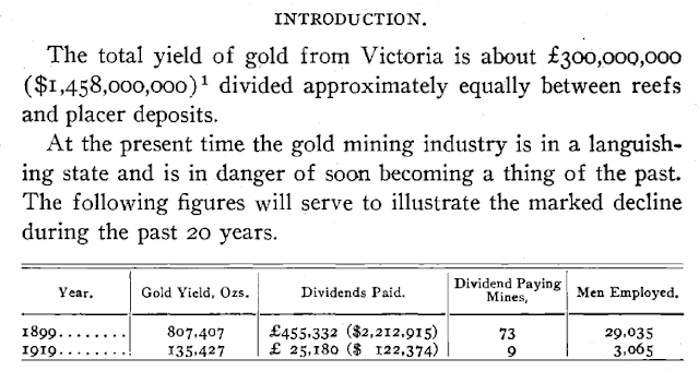
Junner's table. |
Ballarat has also yielded some of the largest gold nuggets of the world. New discoveries of large gold nuggets still continues to this day, thanks to the popularity of metal detectors. A 145-troy ounce nugget was found in 2016 and a 112-troy ounce nugget was found around Ballarat in 2014.
![]() |
Replica of the "Welcome" nugget. Photo by R.A. Kirkham at a museum in Vienna, Austria. |
Sketch of the "Welcome Stranger" from the Discovery Channel Australia. |
The "Latrobe" Nugget. |
Source: Discovery Channel-Australia, Website
The Ballarat District has three types of gold deposits: 1) Orogenic quartz veins (called "Quartz Reefs") hosted by Ordovician turbidites now slates and intrusive rocks including dikes with ladder veins 2) Paleoplacers (Oligocene to Miocene) called "Deep Leads" in the district; these are buried placers overlain by volcanic rocks or younger sediments, and 3) "Shallow Leads" which are placer deposits exposed at the surface.
Historic map of the Ballarat District, showing the leads in yellow following ancient channels. |
Source: Finlay, I.S., Douglas, P.M., 1992. Ballarat 1:100,000 mines and deep leads map geological report. Geological Survey of Victoria Report 94. Ballarat Geological Report
The origin of the large nuggets has been an enigma. A paper by Hughes and others suggest that the origin may be secondary enrichment and growth during deep weathering during the Cenozoic. During this time several periods of tropical weathering occurred including the development of laterites, saprolites and kaolinite. The depth of the water table also varied significantly over this time. Evidence for supergene gold enrichment was identified by Junner in 1921.
The evidence:
- Variations in gold-silver ratios in alluvial deposits and supergene zone of primary deposits.
- Coarsening of gold in the weathering zone.
- Colloform, arborescent and botryoidal gold textures.
- Abundant perfectly crystallized gold in alluvial deposits and in the weather zone of primary deposits.
- An abundance of gold nuggets in some deeply weathered areas.
- Gold concentration in fossil trees and possibly diagenetic pyrite.
![]() |
They are still finding big nuggets in Ballarat! |
Selected References:
Hughes and others, 1998, Lateritic weathering and secondary gold in the Victorian Province [Australia]
Link to Hughes
Junner, N.R., 1921, The geology of the gold occurrences of Victoria, Australia, Economic Geology, vol. 16, p.79-123.
Monday, March 27, 2017
The Ventura Anticline and Oil Field - A Billion Barrels
Since I went to Thousand Oaks high school (1969) in Ventura County, California, I was able to enjoy surfing at the Ventura and LA beaches. On the drive to the beach at Rincon north of Ventura we would pass the Ventura oil field and the offshore drilling platforms. So I looked for some information on the oil field on the internet. My first look was on Google Earth.
The Ventura oil field was discovered in 1919 by Shell Oil Company. The discovery well was drilled to a total depth of 3,498 feet. The oil is produced from depths of up to 12,000 feet. The field has produced nearly one billion barrels of oil through 2008. In 2009, the field was still producing oil from 423 wells. Wikipedia.org/wiki/Ventura_Oil_Field
The large, east-west Ventura anticline is the structure along with faults that controls the location of the pools of oil. The limbs of the fold dip steeply from 30 to 60 degrees. The upper reservoirs are in the Pico Formation (Plio-Pleistocene) and the lower reservoirs are in the Santa Margarita Formation. The underlying Monterey Formation (Miocene) is the source rock for the oil and gas. This formation is rich in organic matter. A total eight zones have produced oil; the named zones are one through eight based on their depth.
Old photographs of some of the oil fields of southern California from the first half of the 20th century. From the Mashable website: mashable.com/2015/12/06/oil-drilling-beaches/ Photographs compiled by Alex Q. Arbuckle, Retronaut, more are available on his website.
Follow the links to find out more about oil fields in southern California.
![]() |
Satellite image of the Ventura Oil Field (Source: Google Earth). |
The Ventura oil field was discovered in 1919 by Shell Oil Company. The discovery well was drilled to a total depth of 3,498 feet. The oil is produced from depths of up to 12,000 feet. The field has produced nearly one billion barrels of oil through 2008. In 2009, the field was still producing oil from 423 wells. Wikipedia.org/wiki/Ventura_Oil_Field
The large, east-west Ventura anticline is the structure along with faults that controls the location of the pools of oil. The limbs of the fold dip steeply from 30 to 60 degrees. The upper reservoirs are in the Pico Formation (Plio-Pleistocene) and the lower reservoirs are in the Santa Margarita Formation. The underlying Monterey Formation (Miocene) is the source rock for the oil and gas. This formation is rich in organic matter. A total eight zones have produced oil; the named zones are one through eight based on their depth.
![]() |
Photo of anticline looking westerly. The Pacific Ocean is in the background. Source: Callan Bentley. blogs.agu.org/mountainbeltway/2013/11/15/friday-fold-ventura-avenue-anticline/. |
The Ventura Oil Feild poster by the City of Ventura, California. http://www.cityofventura.net/files/file/comm-service/14-Oil.pdf |
Old photographs of some of the oil fields of southern California from the first half of the 20th century. From the Mashable website: mashable.com/2015/12/06/oil-drilling-beaches/ Photographs compiled by Alex Q. Arbuckle, Retronaut, more are available on his website.
![]() |
Venice Beach California 1920 |
![]() |
Long Beach California 1929 |
![]() |
Los Angeles area, California 1930 |
![]() |
Huntington Beach, California 1937 |
![]() |
Long Beach, California 1951 during a flood. |
Subscribe to:
Posts (Atom)