 |
| Coarse, crystalline gold from Nevada, about 1.2 troy ozs. |
Saturday, December 31, 2016
Nevada Gold: Hoping for better times in 2017
To all of my friends and Nevada geo's, here is to hoping that 2017 brings higher gold prices and VG in your rock samples!
Wednesday, December 7, 2016
The Big Bonaza: Comstock Lode, Virginia City, Nevada
I stumbled across my 1947 edition of Dan De Quille's book on the history of the discovery, mining and people of the Comstock Lode. He wrote the book while he was a writer for the Territorial Enterprise newspaper in Virginia City, Nevada. He worked at the paper for 31 years (1862-1892). Mark Twain was also writer at the newspaper. For a few years Twain worked with De Quille.
The book was conceived by the Barons of the Comstock: Mackay, Fair, Jones and Ralston. They decided in 1874, about 15 years after the discovery of the bonanza lode that a history of the district should be written. Based in part on the recommendation by Twain to Mackay, De Quille was selected to be the write the history of the Comstock, a newspaper writer that lived and worked on the Comstock. The book was published in 1876. The book is written in a style similar to a series of newspaper articles. It has 439 pages and 73 chapters; that is only an average of six pages per chapter. My favorite thing about the book are the many pen and ink illustrations from the Comstock.
The edition of the book that I bought in Virginia City in 1988 was published by Alfred A. Knopf in 1947. I purchased the book used for $35. The book was originally purchased from The Broadway Store book section. (In the 1960's and before, The Broadway Department stores of California had book sections.) The Broadway sold the book for $5.00.
The original first edition is available via the internet and more recent editions are also available.
The book is a wonderful history of the Comstock and the early days of Nevada including its colorful characters, the mining and milling, the miners, the mine accidents, the fire of 1875 and the fantastic fortunes that were made for the fortunate "few." Pickup a copy of the book for a fascinating read about the Comstock Lode.
 |
| Dan De Quille (William Wright) |
The book was conceived by the Barons of the Comstock: Mackay, Fair, Jones and Ralston. They decided in 1874, about 15 years after the discovery of the bonanza lode that a history of the district should be written. Based in part on the recommendation by Twain to Mackay, De Quille was selected to be the write the history of the Comstock, a newspaper writer that lived and worked on the Comstock. The book was published in 1876. The book is written in a style similar to a series of newspaper articles. It has 439 pages and 73 chapters; that is only an average of six pages per chapter. My favorite thing about the book are the many pen and ink illustrations from the Comstock.
 |
| First edition volume of The Big Bonanza. |
The original first edition is available via the internet and more recent editions are also available.
 |
| Title page for this edition, published to commemorate the discovery of gold and silver in California and Nevada. |
 |
| "Song of the Honest Miner:" One of the many pen and ink illustrations from the book. |
 |
| The RED outline is area burned in the fire of 1875 [The highlighting is mine] |
 |
| Satellite view of Virginia City at the same angle and direction as the above lithograph. Source: Google Earth. |
Thursday, November 17, 2016
Pacific: Simon Winchester's New Collection of Essays on Geology, Colonies Lost, Nature and Wars
The UK's Simon Winchester, 72-year old best selling author, has recently released a new book about natural and human-caused events that occurred around and in the Pacific Ocean. It is a fascinating read filled with bits of history and the natural events that took place in the Pacific. It also brings to life some unimaginable stories about the formation of the Sony Corporation and the transistor radio. There is a chapter on the discovery and confirmation of continental drift, now known as "Plate Tectonics." The story of the discovery of the deep sea, black smokers and life in the deep ocean.It is an eclectic collection of stories of non-fiction, written in easy-reading prose.

This is the table of contents of the book which I have made brief annotations of what the various chapters are about. As you can read it is a very wide range of topics. All the chapters are enjoyable and will improve your knowledge of many interesting events. The book will be enjoyed by geologists, history buffs, environmentalists, military buffs, nerds and anyone desiring to learn about their world.

Other Winchester books that I have read and recommend are: The Map That Changed the World, about William Smith's geologic mapping in the British Isles, Krakatoa, and The Man Who Loved China. And there are many more that I have yet to read but plan to in the near future, specifically "Korea."

Thanks for viewing this post and please comment. dle
Friday, November 4, 2016
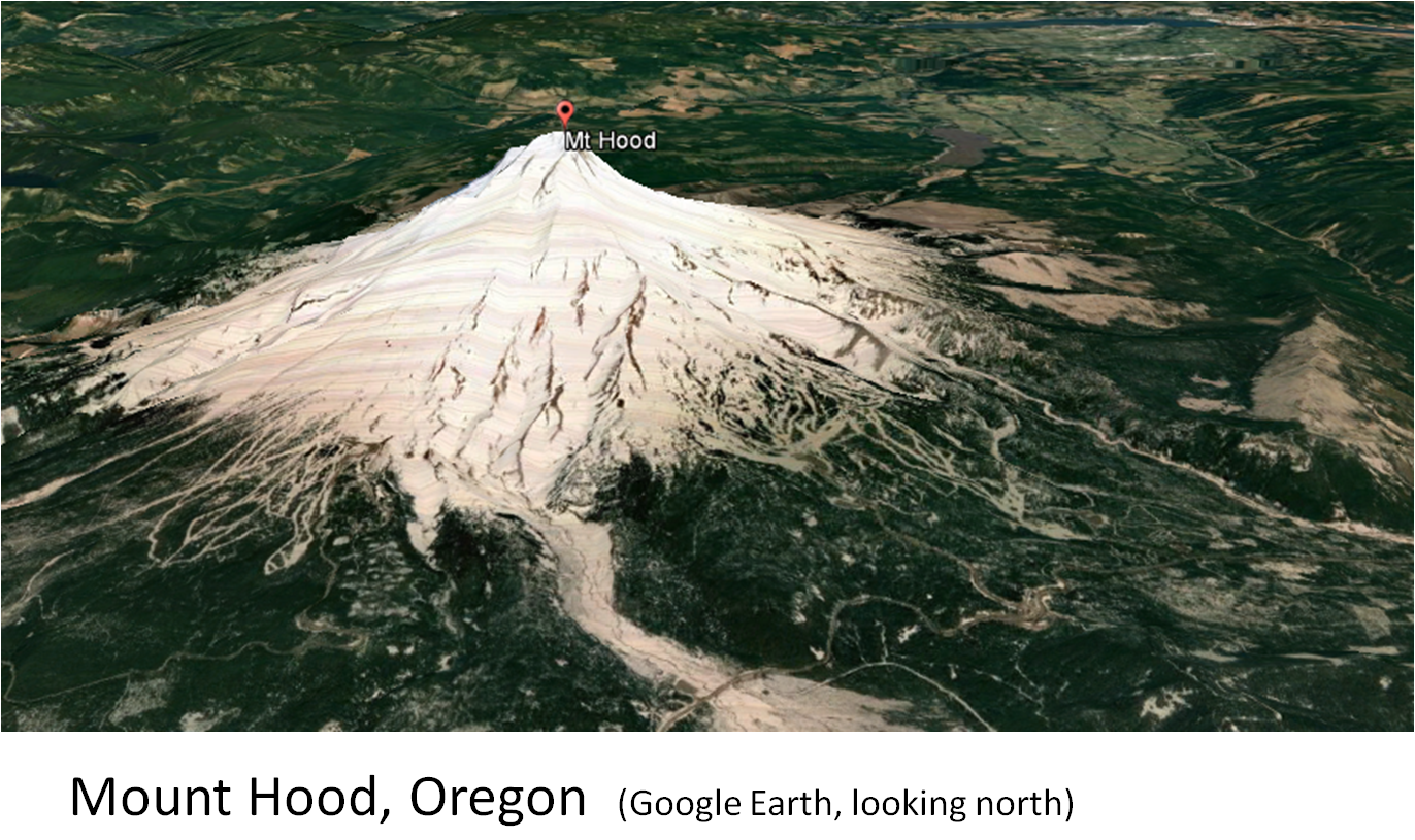
The Cascade Volcanoes as seen in Satellite Images
The Cascade volcanoes are a fantastic result of plates tectonics. Seven of the volcanoes have erupted in the last 200 years and three of these have erupted in the last 100 years. The eruption of Mount St. Helens on May 18, 1980 was both spectacular and tragic. I am sure many of you saw some of the ash clouds and eruptions. I saw it once from a passenger jet flying east from Seattle; mainly steam and some ash.
The Cascade volcanic arc extends northward from northern California, through Oregon and Washington, extending into British Columbia (Mount Garibaldi and Mount Meager).
 | ||
| Cascade volcanic arc formed by the subduction of the Juan de Fuca plate beneath the North American plate. USGS
|


 |
| Oblique view of Mount St. Helens showing the various volcanic deposits and the lava domes (USGS). The view is approximately the same as the satellite image in the previous illustration. |

 |
| Note the well developed flow ogives (pressure ridges) emanating from the felsic volcanic dome field. |


A first hand account of the eruption of Mt. St. Helens is available. The book is: Mt. St. Helens, Surviving the Stone Wind. The author is Catherine Hickson.

 |
| Catherine Hickson |
Thursday, October 20, 2016
Corkscrew Mtn, Toroda Creek Graben, Washington
Corkscrew Mountain is an interesting geological formation composed of Tertiary basalt flows in northern Washington. It is located 2.5 miles west of Toroda and north of Toroda Creek. Volcanic rocks form many interesting landscapes.
 The photos below show several basalt flows exhibiting columnar jointing along with the flow tops and bottoms. The trough shape of the flows may indicate that they flowed down a gentle valley. The image on the right is the authors concept of the original orientation of the basalt flows.
It is out of the way for most people. But if you are in the area, it is worth a drive by, a look and a photo.
Thanks to Tom Johnson, Kinross geologist, for pointing it out to me several years ago.
 |
| Corkscrew Mountain shown on the Toroda USGS 7.5' topo. |
 The photos below show several basalt flows exhibiting columnar jointing along with the flow tops and bottoms. The trough shape of the flows may indicate that they flowed down a gentle valley. The image on the right is the authors concept of the original orientation of the basalt flows.
 |
| Oblique view of Corkscrew Mountain viewed on Google Earth. |
Thanks to Tom Johnson, Kinross geologist, for pointing it out to me several years ago.
Wednesday, September 28, 2016
Borate Mining in Death Valley, California: 1960's to 2005
In 1960, Kern County Land purchased the claims from the Pacific Coast Borax with the famed 20 mule team wagons. They paid $200,000 for the claims that contained the Boraxo, Billie and Sigma borate deposits.
Tenneco's foray into borate mining lasted until 1976 when it sold its borate properties to Owens Corning vis the subsidiary of American Borate Company (ABC). Owens Corning was the largest customer to the borate products. In 1990, Owens Corning spun-off/sold ABC. ABC intermittently produced borates from the Billie mine from 1990 until 2005.
 |
| Borate deposits of Death Valley and the Armargosa area (Source: Barker and Barker, 1985). |
 |
| The famous 20 Mule Train hauling borates. |

The Boraxo and Sigma pits were mined by Tenneco in the 1970's. The borates were trucked the mill in Nevada north of Death Valley Junction. Exploration and development drilling conducted within the monument. The Billie deposit was drilled out on a 100-foot rectangular grid. Conventional rotary drilling was done until borates were encountered and then the deposit was core drilled. Tenneco was not allowed to build drill roads, so the drill and 4WD vehicles were driven cross country over the boulder-strewn wash.
The borate deposits of Death Valley are in the Pliocene Furnace Creek Formation. They are stratiform deposits that form in a lacustrine environment. The "ore" is composed of colemanite, probertite and ulexite. Typical grade is approximately 22% boron. The Boraxo and Billie mines yielded beautiful colemanite crystals some of which are honey colored.
 |
| Three colemanite specimens and one probertite (lower left); collected from the Boraxo pit in 1974. |
 |
Satellite image of a portion of Furnace Creek showing the Boraxo and Sigma open pit borate mines and the surface projection (approximate) of the Billie borate deposit that was mined underground by American Borate Company. The north-south road that leads to the shaft is immediately east of the National Monument boundary.
|

 |
| Screen shot of YouTube video of a flyover of the Billie mine (click on link below). |

 |
Cross section of the Boraxo deposit. The deposit was mined from an open pit by Tenneco Mining and then the portion that extends down-dip from the pit was mined underground with a continuous miner. (Source: Wilson, 1976).
|
 |
Underground mine development for the Billie mine, Agapito is tasked with closure of the mine for American Borate Company (Source: Agapito Associates, Inc. website).
|
A front-page article in the Los Angeles Times on September 17, 1975 by Robert A. Jones warning the Tenneco Mining may someday have an open pit strip mine in the view of the Zabriskie Point scenic turnout. The news item was the result of claim staking by Tenneco in the vicinity of scenic area. The monument's superintendent James B. Thompson was quoted saying "We'll be able to stand right here and watch trucks haul away part of the view. And if the legal situation doesn't change, we'll be helpless to stop it."
Death Valley Nation Monument was an exception in that mining was allowed because of existing talc and borate mines at the time that it was designated as a monument by President Herbert Hoover in 1933. In 1994, Death Valley National Park was created.
 |
| Front-page photo from the LA Times on September 15, 1975. |
Additional articles in the Times in 1975 and 1976 resulted in the banning of mining in Death Valley and eventually its status was changed to a National Park. However, American Borate Company was eventually allowed to mine the Billie borate deposit since it was an underground mine. The shaft and head frame were just east of the monument and the only surface structure for the mine in the monument was the secondary escape way.
 |
| Zabriskie Point Death Valley has not be trucked away as predicted by the LA Times (Photo 2007). |
Suggested Reading:
Barker, C. E., and Barker, J. M., 1985, A re-evaluation of the origin and diagenesis of borate deposits, Death Valley region, California; in J. M. Barker and S. J. Lefond, eds., Borates-Economic Geology and Production: Symposium Proceedings, SME-AIME, New York, p. 101-35.
Barker, J. M., and Wilson, J. L., 1976, Borate deposits in the Death Valley region: Nevada Bureau of Mines and Geology, Special Report 26, p. 22-32.
McAllister, J.F, 1970, Geology of the Furnace Creek borate area, Death Valley, Inyo County, California: California Division of Mines and Geology Map Sheet 14, 9 p. 1:24,000.
Wilson, J.L., 1976, Geology and engineering aspects of Boraxo pit, Death Valley, California: unpublished M.S. thesis, University of Southern California, 95 p.
Monday, August 22, 2016
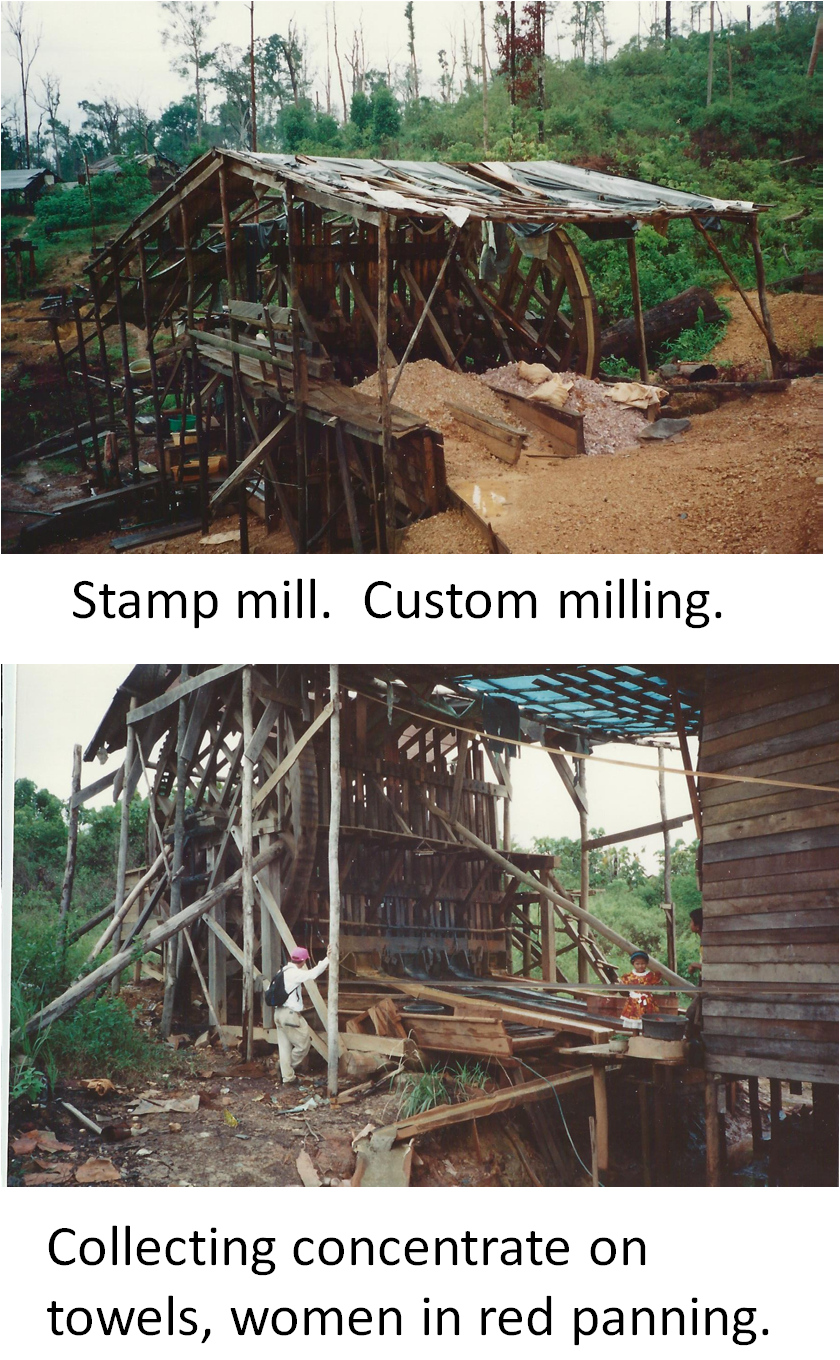
Borneo: A Photo Tour of Artisanal Gold Mining in 1993
In 1993, I visited the Pangkut area of Borneo (Kalimantan, Indonesia) to examine the gold potential for the mining and exploration company that I was working for in the US. One of the geologists with me was Casey Danielson. The area has long been an home to many Artisanal and Small-scale Gold Mining (ASGM) for centuries. The Dutch colonized the Indonesia in the 1600's and 1800's. The islands were often referred to as the Spice Islands.
The mining is placer, hydraulic and shallow underground mining (shafts and adits). The gold is recovered by panning, stamp mills and with the use of mercury. In 2008, the estimated production from Kalimantan 13.3 tonnes of gold (426,000 troy ounces) by 43,000 small-scale miners (Stapper, Daniel, 2011, Artisanal Gold Mining, Mercury and Sediment in Central Kalimantan, Indonesia: MSc, University of Victoria). [Thesis is available on-line]
The photos in the following are from the trip in 1993. It is reminiscent of mining in the early gold rush days in California.


Tuesday, July 19, 2016
Archie's Rule of Thumb for Mineral Deposit Economics
Archibald M. Bell (1906 - 1991) was a mining geologist and long time VP of Exploration for Noranda. Later he was a successful consulting geologist. Bell was an ore finder (Pamour, Timmins and Copper Mountain, Quebec). He was inducted into the Canadian Mining Hall of Fame in 1995. Bell is the source of Archie's Rule.

Several years ago I came across a reference to "Archie's Rule" which is a rule of thumb method for evaluating the economic viability of a mineral deposit.
Simply and elegantly stated: To be economic a deposit must have a recovered value of twice the all-in operating costs. This allows for the covering of the capital costs. The all-in costs includes mining, processing, refining, etc. It assumes that the mine life will be long enough to extend over multiple metal price cycles.
Clearly not a NI 43-101 level of evaluation, but a useful tool in evaluating mineral deposits.
Source: Canadian Mining Hall of Fame
Several years ago I came across a reference to "Archie's Rule" which is a rule of thumb method for evaluating the economic viability of a mineral deposit.
Simply and elegantly stated: To be economic a deposit must have a recovered value of twice the all-in operating costs. This allows for the covering of the capital costs. The all-in costs includes mining, processing, refining, etc. It assumes that the mine life will be long enough to extend over multiple metal price cycles.
Clearly not a NI 43-101 level of evaluation, but a useful tool in evaluating mineral deposits.
Tuesday, July 5, 2016
The Pink and White Terraces of Lake Rotomahana, NZ
Greetings from Texas,
On April 26, 2016, Robin Wylie of the BBC posted an interesting story on the web about the rediscovery of the Pink and White Terraces on the north island of New Zealand.
http://www.bbc.com/earth/story/20160427-a-natural-wonder-lost-to-a-volcano-has-been-rediscovered
The Pink and White Terraces of Lake Rotomahana and the nearby volcano of Mount Tarawera are hot springs sinter deposits. The sinter is composed of fine-grained quartz deposited by hydrothermal water of a geothermal field. The Maori called the terraces taonga which means treasure. They were also a popular tourist attraction for the well-to-travelers on the 19th century until 1886. The terraces were "destroyed" by the eruption of Mount Tarawera on June 10, 1886. The eruption was heard in Christchurch 400 miles away. The locals, the native New Zealand Maoris, did not see the eruption from their villages. However, 120 people, mostly Maoris were killed by the fallout of debris from the eruption.
Only one person saw the eruption. Henry Burt was 7 miles east of the eruption and had a clear view of the volcanic eruption. He told a journalist the lake looked like a "huge boiling cauldron bubbling in all directions." After the eruption the terraces were no longed visible. The New Zealanders had lost a valuable tourist attraction in the violent act of nature.
What we do have are beautiful watercolors of the area by Charles Blomfield, along with black and white photos by various individuals (some hand colored). The watercolor is below. The Pink Terraces are in the foreground and the White Terraces are in the distance.


Fortunately, recent scientific research has rediscovered the terraces below the waters and sediment of Lake Rotomahana. It is a fantastic story. It is described in the research articles by C.E.J de Ronde, et.al. in the Journal of Volcanology and Geothermal Research: Elsevier, volume 314, March 15, 2016. One of the articles is titled: The Pink and White Terraces of Lake Rotomahana: what was their fate after the 1886 Tarawera Rift eruption? (p.126-141).


On April 26, 2016, Robin Wylie of the BBC posted an interesting story on the web about the rediscovery of the Pink and White Terraces on the north island of New Zealand.
http://www.bbc.com/earth/story/20160427-a-natural-wonder-lost-to-a-volcano-has-been-rediscovered
 |
Geologic map by Ferdinand von Hochstetter (1859) of the Rotamahana or Warm Lake (Left). The sinter deposits are shown in yellow and are within a volcanic field. Travel poster for the Pink and White Terraces (Upper right). Bathers in the warm water of the hot springs (Lower right).
|
Only one person saw the eruption. Henry Burt was 7 miles east of the eruption and had a clear view of the volcanic eruption. He told a journalist the lake looked like a "huge boiling cauldron bubbling in all directions." After the eruption the terraces were no longed visible. The New Zealanders had lost a valuable tourist attraction in the violent act of nature.
What we do have are beautiful watercolors of the area by Charles Blomfield, along with black and white photos by various individuals (some hand colored). The watercolor is below. The Pink Terraces are in the foreground and the White Terraces are in the distance.


Fortunately, recent scientific research has rediscovered the terraces below the waters and sediment of Lake Rotomahana. It is a fantastic story. It is described in the research articles by C.E.J de Ronde, et.al. in the Journal of Volcanology and Geothermal Research: Elsevier, volume 314, March 15, 2016. One of the articles is titled: The Pink and White Terraces of Lake Rotomahana: what was their fate after the 1886 Tarawera Rift eruption? (p.126-141).


Many thanks to Robin Wylie of the BBC for bringing this to the attention of the world and for the research by de Ronde and others for rediscovery the Pink and White Terraces of New Zealand.
It is worth your time to take a look at what else is available on the web on this story about the wonders of nature.
If you enjoyed this post, please comment. dle
Subscribe to:
Posts (Atom)